

 Highway Exits and Interchanges Guide – Installation and Tips (PDF)
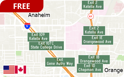
FREE point layers of all signed and numbered highway exits are now downloadable for users of the current version of Maptitude that are licensed to use the USA or Canada Country Packages.
The highway exit layer is a nationwide reference for all signed and numbered highway exits, including the latitude and longitude, number, and name for each one. It provides some of the key information needed to evaluate sites for network accessibility based on proximity to major highways and interchanges.
Highlights:
- Allows site location analysts to determine the nearest highway interchange
- Can be used to determine the proximity to a chosen or desired interchange
- Applications include site location assessment, commercial real estate, franchise development, and accessibility studies
- Can be used in conjunction with the AADT data (U.S. only) to determine traffic volumes around a chosen exit
A PDF guide is installed with the data and includes information on the map layer as well as tips for analyzing and using the data.