


 PLSS & TXSS Data Guide – Installation and Tips (PDF)
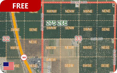
Free area layers of the Public Land Survey System (PLSS) and of the Texas Survey System (TXSS) are now downloadable for free for use with the current version of Maptitude.
The PLSS divides large areas of the USA into townships and sections (First Divisions and Second Divisions). PLSS layers provided are:
- PLSS Township
- PLSS First Division
- PLSS Second Division
- PLSS Special Survey
- Survey System
- Meandering Water
- Conflicted Area
The Texas Land Survey Layer splits the state into tracts, sections, and labors. TXSS layers provided are:
- Texas RRC District
- Texas Land Survey
- Texas Bay Tract
A PDF is installed with the data and includes information on the map layers as well as tips for analyzing and using the data.

Reviews
There are no reviews yet.